
Find Sanger Neighbors by Block
A block lookup works best when each source is assigned one job. Fresno GIS shows the parcel pattern. The assessment roll gives a January 1 owner and tax-mail snapshot. The Recorder supplies recorded parties and instruments. Directories can show listed occupants from a past date, while permits show work and named applicants. Voter data is a restricted channel, not a public browse tool. That mix can help explain a block without turning an owner record into proof of who lives there.
| Source | What It Shows About a Block | Access |
|---|---|---|
| Fresno GIS parcel viewer | Parcel geometry, map context, jurisdiction, and published layers | Free visual browse |
| Fresno County assessment roll | January 1 owner or controller and tax-mail context | Web, counter, or roll product subject to restrictions |
| Fresno County Recorder | Recorded parties, deeds, liens, and document dates | Name or document search; free office view |
| Directories and papers | Listed occupants, subscribers, notices, and older block clues | Heritage Center and microfilm |
| Sanger permits and code cases | Applicants, contractors, project locations, and work chronology | iWorQ or focused request |
| Voter file | Limited registration geography when legally approved | Approved statutory purpose only |
Owners, occupants, voters, and community members are different sets. A tax-mail address may point away from the parcel. A directory entry may be old or incomplete. A permit may name an applicant who never lived at the project. These records are useful when their dates and roles stay visible.
Map Sanger Parcels Around One Address
The adjacent-parcel method starts with one target on the Fresno County GIS viewer. A buffer is not needed for immediate adjacency. The map itself provides the cleanest path from the target parcel to the parcels that share a boundary or sit across the street.
- Locate the address and zoom until individual parcel polygons appear.
- Use Identify or Select on the target, then note its situs, APN, legal or map attributes, and jurisdiction.
- Click each parcel sharing a boundary and each parcel across the street. Record the APN and situs before seeking an owner record.
- Resolve ownership through an allowed assessment-roll, counter, or Recorder route. If a defined radius is used, state the radius and confirm the city boundary.
That process keeps a map relationship separate from a people claim. For a full named-street chain, use the Sanger street directory workflow after the immediate block is marked.
January 1 Owners and 93657 Boundaries
The Fresno County assessment roll is an annual snapshot. It identifies the owner or controller on January 1, assessed land and improvement values, exemptions, and a tax-bill mailing address. It does not identify every person at the situs, and the tax collector's payment record is a different channel.
Fresno's Assessor reduced public online address/APN matching effective January 1, 2025, citing Government Code section 7928.205 protections for elected and appointed officials. The alternatives are a county parcel map, roll product, public counter, or recorded instrument. ZIP Code 93657 also extends beyond incorporated Sanger into rural and eastern Fresno County territory, so use USPS ZIP Lookup for mailing geography and GIS for jurisdiction. A Sanger mailing label does not decide which office holds a block record.
Sanger Voter Data Has Narrow Limits
California My Voter Status is a personal self-lookup, not a way to browse Sanger neighbors. Its prompts can ask for first name, last name, date of birth, county, and California identification or Social Security digits. A match returns registration and status details, districts, polling or vote-by-mail information, and ballot-status features. It never reveals ballot choices.
Elections Code section 2194 limits voter-registration information to election, scholarly, journalistic, political, or governmental purposes determined under law. Commercial use is a misdemeanor. Driver-license numbers, Social Security numbers, and signatures are not released, and confidential voters under sections 2166, 2166.5, and 2166.7 have restricted records. A full voter-file application asks for the requester, geography, project, statutory purpose, delivery method, identification, certification, and payment. Fresno County accepts approved applications by email at ElectionsIT@fresnocountyca.gov, by mail, or in person at 2221 Kern Street in Fresno. Do not treat an approved file as a casual block list.
Statewide voter files cost $100, and up to ten named-voter records cost $30 each with a $100 cap. Fresno options include walking lists, election history, status filters, precinct-to-district work, and delivery by USB, CD, pickup, USPS, or FTP. The form and the approved purpose control access, not simple curiosity about who your neighbors are.
Recorder, Directories, and Permits
The Fresno Recorder searches by instrument number and grantor or grantee name rather than a single parcel file. Search last name, first name, variants, and business names, then match the legal description and date. Pre-1981 copy requests need book, page, and year. Free office inspection is available through the Eagle Recording Kiosk, while regular and certified copies use the county's purchase route.
The Sanger iWorQ code-request record shows the kind of address-linked municipal view that can supplement a map.
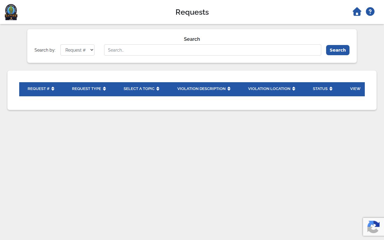
Inside city limits, iWorQ offers building-permit and code-request searches. Permit results can show Primary Contractor, Parcel Address, Permit Type, Applicant Address, inspection request, and View. Code results can show request number, topic, violation description, location, status, and View. The Building Division is the local route; older permit jackets may need a focused request, and Fresno County Public Works or Planning handles unincorporated 93657 property.
For older blocks, the Heritage Center's Haines criss-cross begins in 1973, while Polk-Husted, telephone books, census schedules through 1950, and the Sanger Herald's 1920 to 2008 microfilm add dated clues. They show listed occupants, subscribers, notices, or history, not every current person.
Community Records Without Private Rosters
No verified City of Sanger umbrella neighborhood association directory with a public member or resident roster was located in the official sources reviewed. That absence matters. It is better to name the public community records that exist than to infer an HOA, block club, congregation, or membership list from a map.
| Community resource | Useful block context | Access |
|---|---|---|
| City of Sanger | Public meetings, planning, council records, and department routes | Official city site and focused request |
| Sanger Branch Library | Catalog, databases, local referral, and community history | 1812 7th Street, phone, or posted hours |
| Fresno Heritage Center | Directories, Sanborn maps, papers, and archival leads | Library collections and staff help |
| Planning and district records | Jurisdiction, school or service boundaries, and public meeting context | Agency records, not private member lists |
The Sanger Branch began as a 1910 reading room, received a 1916 Carnegie building grant, and moved to its current branch in 1967. Those public history resources can help neighbors understand a block without exposing a private roster.
A block can also be read as a small timeline. Sanborn editions from 1891, 1893, 1898, 1907, 1916, 1923, and the updates through 1945 show footprints, uses, street labels, and fire infrastructure. Polk-Husted directories and rural telephone books add names or subscribers near the same period. Haines Criss-Cross begins around 1973. A later permit or code record can then show when a structure changed, while the public record still stops short of naming everyone who used it.
Public meetings can supply context without turning civic material into a people list. Sanger agenda searches can be narrowed by date range, search phrase, and categories such as City Council, Planning Commission, Citizen’s Oversight Committee, or Youth Council. Council and Planning items are visible from 2015, Citizen Oversight from 2017, and Youth Council from 2018. These records may name speakers, applicants, or public officials, but they should be read as meeting evidence, not as proof of a private neighbor’s address.
Official Rolls and Commercial Neighbor Tools
Official records and commercial neighbor-search tools answer different questions. The comparison belongs at the method level, not as a list of brand names.
| Source category | Best evidence | Limits |
|---|---|---|
| Official GIS, assessment, and Recorder records | Parcel shape, dated owner snapshot, legal instrument, jurisdiction | Separate systems, access rules, and no complete occupant list |
| Commercial neighbor-search category | Convenience view built from mixed public and private data | May be stale, merged, incomplete, or unclear about source and date |
| City and library community records | Meetings, planning, history, and public service context | Do not create a private association or household roster |
For Sanger neighbors, a traceable official record is usually slower but clearer about what a field means. A convenience result should never override the parcel map, dated roll, Recorder index, or custodian response.
Privacy Limits for Sanger Neighbors
Safe at Home can give eligible survivors and other protected groups a substitute mailing address and confidential voter registration. Protected officials may have internet restrictions. Sealed court material, restricted voter records, utility accounts, and delivery data create deliberate gaps. A missing name should stay missing rather than be filled from a commercial inference or a guess about the household.
Lawful use. Sanger neighbors can be researched for personal history, reconnecting, civic awareness, and lawful safety planning. Do not use parcel, voter, directory, or permit clues to watch, stalk, harass, intimidate, or harm a person.
The sound boundary is simple: describe the record, date it, name its custodian, and respect the person who is not represented in it. Public does not mean complete.
Keep the target address, APN, map view, and source date together. A parcel across the street may be outside incorporated Sanger even when the postal label matches. A parcel beside the target may have a different legal description, an owner mailing address elsewhere, or a protected record that cannot be displayed. Those are ordinary features of the records system, not invitations to fill the gap with a guess.
For a family or civic project, preserve only the fields needed to explain the block. A dated deed party, a directory entry, a permit event, or a public meeting can support a narrow conclusion. It cannot establish every household member or a person’s present whereabouts. When the question changes from the immediate block to a full street, hand the work to the Sanger street directory workflow and keep the two scopes distinct.